


An earthquake in Bali
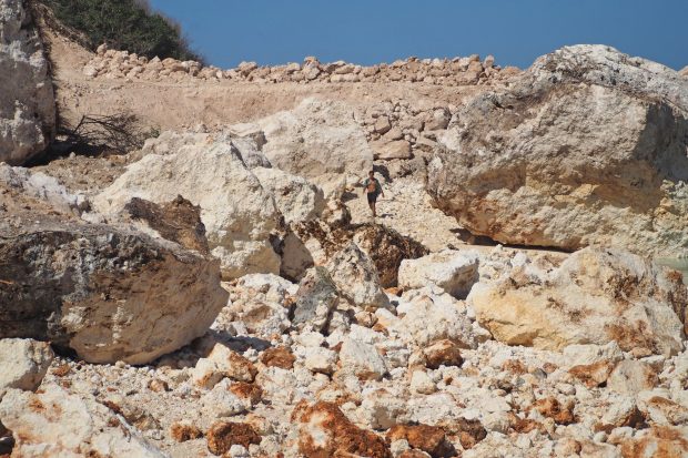
BALI, July 16, 2019 (Xinhua) — A tourist walks down a collapsed cliff after an earthquake in Nusa Dua, Bali, Indonesia, July 16, 2019.
An earthquake of 6.0 magnitude struck off Indonesia’s Bali Island earlier on Tuesday, July 16, 2019 at 7.18 WIB. The epicenter of this earthquake is in 83 southwest Nusa Dua, a depth of 104 kilometers. Although it does not have the potential for a tsunami, the earthquake has a unique mechanism, namely a combination of upward and horizontal fault movements. “The analysis of the source mechanism shows that this earthquake was generated by rock deformation with the mechanism of oblique thrust,” said the Head of the Earthquake Center and Tsunami Meteorology, Climatology and Geophysics Agency (BMKG). BMKG released that the earthquake shock was most felt in the Badung area, with the intensity of V MMI. With that intensity, buildings can experience mild to moderate damage. Based on Kompas.com news report, the mechanism of the oblique thrust earthquake is unique.
An earthquake with this mechanism had occurred in Aceh on April 11, 2012. It’s just that the two locations are different. The Aceh earthquake is centered on the outer rise area, while the Bali earthquake is located in the subduction zone. Even though it is centered in the subduction zone, the Bali earthquake does not cause a tsunami because of 32 things: the depth is more than 70 km and the magnitude is moderate because only M is 5.8. In contrast, the Aceh earthquake in 2012 could generate a tsunami even though it was not centered in the subduction zone. Two reasons are the character of the outer rise region and the large magnitude, reaching M 8.5. The earthquake was the largest oblique earthquake (dominated by horizontal faults) in history.
Earthquake in Maluku
On Sunday, July 14, 2019, another earthquake with a magnitude of 7.7 also occurred in Labuha, South Halmahera, North Maluku. Tsunami experts Abdul Muhari (from Ministry of Maritime Affairs and Fisheries) and Widjo Kongko (from the Agency for the Assessment and Application of Technology) made declarations based on data from the Geospatial Information Agency (BIG). Widjo said that “there was a tsunami less than 20 cm observed at Gebe Tidal Station, approximately 35 minutes after the main earthquake.” Tsunamis that occur are small because, in addition, they do not occur in the meeting zone of two plates, the mechanism of the earthquake is the horizontal fault. Large tsunamis are usually triggered by a vertical earthquake mechanism. Abdul said that, after the main earthquake in North Maluku, 52 aftershocks (as of early Monday occurred) took place in the western part of South Halmahera. However, “there is not one tidal station on the west side (Ternate Island, Tidore, and Jailolo) who caught the tsunami signal”, he declared. Abdul said that although the source was clear, experts still had to examine the exact way the tsunami was generated from the North Maluku earthquake. Based on the modeling, Widjo revealed that a small tsunami could also occur on Weda Island. The earthquake yesterday produced energy equivalent to 50 times the Hiroshima bomb with a collapse of 70 x 18 kilometers and slipped 2.8 meters. Until now, the team is still taking care of the victims and the impact of the earthquake in North Maluku.