Absence of maritime boundary between India and Pakistan brings miseries to fishermen of two nations
It has become a tradition on the part of rulers of India and Pakistan to release detained fishermen on certain occasions as a gesture of good will but at the same time their respective security agencies continue arresting the fishermen, seizing their boats and throwing them into prisons to languish for years, as the issue of territorial waters between the two countries, which is the main cause of miseries for the fishing communities, remains unsolved for seven decades.

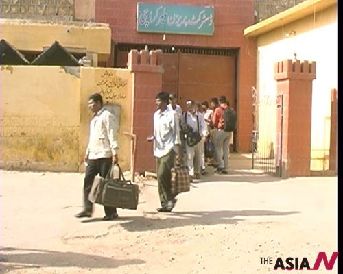
A bus carrying freed Indian fishermen leaving Malir Jail of Karachi to transport them to Indian border at Wagha near Lahore (Photo: Sami Memon)
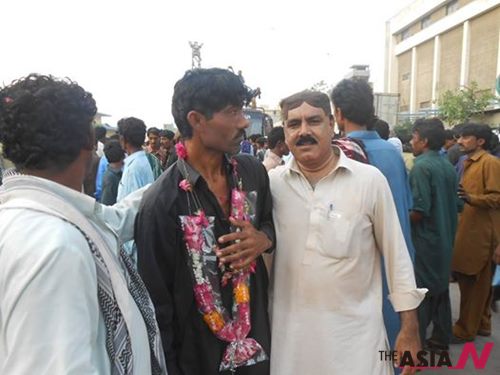
Recently, Pakistan had released 151 Indian fishermen and 57 boats as a gesture of good will a day ahead of Pakistan Prime Minister Mian Nawaz Sharif’s visit to Delhi to attend oath-taking ceremony of newly elected Indian Prime Minister Narendra Modi and reciprocating the gesture, the India also freed 30 fishermen and five other Pakistani civilians lodged in various jails of Indian state of Gujarat.
Hundreds of Pakistani and Indian fishermen are still languishing in jails for accidentally crossing the sea border. An official of Pakistan Fisherfolk Forum, a non-government organization working for welfare of fishing community, told AsiaN that around 450 Pakistani fishermen are lodged in Indian jails.
The two nuclear-power neighboring countries have fought three wars for their claims over Himalayan state Kashmir while disputes over river waters and the non-existence of demarcation at territorial waters have further caused strain in their relations.
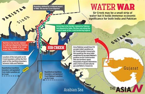
The issue of territorial waters relates to Sir Creek, which is a 96 km strip of water that is disputed between India and Pakistan in the Rann of Kutch marshland. The creek, which opens up into the Arabian Sea, divides the Kutch region of the Indian state of Gujarat with the Sindh province of Pakistan. Originally and locally it is called ‘Baan Ganga’. Sir Creek is named after the British representative, who had surveyed this region.
The long-standing dispute hinges in the actual demarcation from the mouth of Sir Creek to the top of Sir Creek, and from the top of Sir Creek eastward to a point on the line designated on the Western Terminus. From this point onwards, the boundary is unambiguously fixed as defined by the Tribunal Award of 1968.
The creek itself is located in the uninhabited marshlands. During the monsoon season between June and September, the creek floods its banks and envelops the low-lying salty mudflats around it. During the winter season, the area is home to flamingoes and other migratory birds.
Of the territorial disputes between the two countries, Sir Creek was once considered the easiest to solve. However, what was once a comparatively unimportant strip of water is being talked up as a potential source of natural gas. Prime Minister Modi, who was earlier the chief minister of Gujarat, had called for those energy reserves to be fully exploited. In a letter to the Central government he had stated that handing over Sir Creek to Pakistan would be a blunder. Modi is said having mixed Sir Creek into the election brew of Gujarat, rather than make a substantive demarche on the issue.
The dispute baffles those fishing on both sides of the ambiguous border. Mohammad Ali Shah, the chairman of the Pakistan Fisherfolk Forum, called for small boats from both countries to be allowed to fish all over the creek. He says those fishing the waters from both India and Pakistan treat each other like comrades when they encounter each other, but only the governments are hostile to each other. “It is a fight between two governments, not the people,” he said.
In the absence of maritime boundary between India and Pakistan, the frequent trespassing and violation of respective territorial waters takes place. The Indian fishermen and their boats are caught by Pakistan Maritime Security Agency while Pakistani fishermen are arrested by Indian Coast Guards. In certain cases, the Indian Coast Guards open fires on Pakistani fishermen, the Pakistan Fisherfolk Forum official told.
The long-standing territorial disputes and military conflicts between India and Pakistan have led to vigilant and strict patrolling of territorial waters in the Arabian Sea and the coastline shared along the Indian state of Gujarat and the Pakistani province of Sind by the Maritime Security Agency of Pakistan and the Indian Coast Guards.
The absence of a physical boundary and lack of proper demarcation leaves small fishing boats susceptible to illegally crossing territorial waters. The problem is aggravated by the failure to officially determine the maritime boundary between the two nations. Most local fishermen possess no navigational tools and are unable or incapable of determine their location.
For most of the time, the situation of imprisoned fishermen remained unknown to their home countries and people. Coastal villages often report the disappearance of fishing boats and fishermen from their village but their whereabouts remain unclear for many years. Some NGOs and human rights organizations had been working to petition both governments and represent the families of imprisoned fishermen.
Of far greater significance is the need to determine the maritime boundary between India and Pakistan, which remains undefined 67 years after partition of Indian subcontinent in 1947. Pakistan and Indian officials have met several times to find a solution.
India has suggested that the maritime boundary be determined first by beginning with mutually acceptable points from the shore line of India and Pakistan, 250 km out to sea, and working inwards to plot the boundary.
The joint statements issued after the India-Pakistan talks on May 21, 2011, and June 19, 2012, speak of the need to demarcate “the land boundary in the Sir Creek area and the delimitation of the International Maritime Boundary between Pakistan and India.” A joint survey of Sir Creek was taken up in two phases in January and February 2007. This has generated a joint map of the area, which was authenticated by both sides at the fourth round of talks in 2008 in Islamabad when copies of the joint map were also exchanged.


