


Typhoon Mitag likely to hit South Korea’s southern coast this week
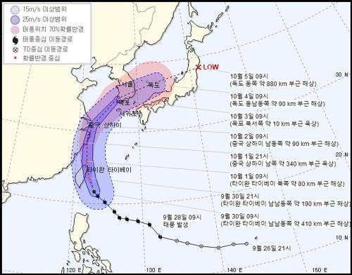
This image provided by the Korea Meteorological Administration shows the predicted course of Typhoon Mitag (Yonhap)
Seoul: Typhoon Mitag is expected to make landfall on South Korea’s southwest coast on Thursday but its strength may be weaker than anticipated after passing through Taiwan and the Chinese mainland, the local meteorological agency said.
Mitag, the season’s 18th typhoon and the seventh to affect the Korean Peninsula this year, could bring powerful winds and heavy rain to the southern parts of the peninsula, the Korea Meteorological Administration (KMA) said on Monday, calling for thorough preparations to prevent damage.
Mitag was moving west-northwest from waters 290 kilometers south-southeast of Taipei at a speed of 22 km per hour as of 3p.m. Monday. Its central pressure was reported to be 970 hectopascals, with a maximum wind speed of 35 meters per second.
It was developing into a mid-strength typhoon as of Monday afternoon. It is expected to reach about 210 km south of Shanghai at around 3 p.m. on Wednesday, after skirting Taiwan early Tuesday.
It will then move northeast toward the Korean Peninsula, likely to pass through the western coast of the southern resort island of Jeju between Wednesday and Thursday, then reach the vicinity of the southwestern coastal city of Mokpo, South Jeolla Province early Thursday, the KMA said.
By the time Mitag makes landfall in South Korea, the typhoon is expected to have weakened to a small-scale storm, they said. Mitag will reach waters about 90 km east-southeast of Dokdo in the East Sea at 9 a.m. Friday, they added.
“The authorities are closely watching the movement of Typhoon Mitag as it could lose its strength and speed while passing through the coastal regions of Taiwan or China,” a KMA forecaster said.
Meanwhile, weather forecasters on Jeju said the island will come under the influence of Typhoon Mitag beginning Tuesday. Rain of 30-50 millimeters per hour will begin on Jeju Island early Tuesday morning and a mix of strong winds and heavy rain is forecast for Wednesday.
YONHAP